A Backpacker's Guide to Big Sur
- Apr 27, 2018
- 6 min read
Updated: Aug 10, 2021
By Nick Dudler
Leaning out the window, music blasting, wind in my hair down the Highway 1 in one of the most beautiful stretches of California highway you can imagine-- I wish I could recreate the moment a thousand times! I looked out towards the Pacific and then swiveled to face the hilly terrain that extended up from the shoreline. It was a Saturday morning in April; Me and 8 other friends from Santa Clara had left early in the morning to attempt one of the most challenging Big Sur hikes-- an in and out backpacking trail from Highway 1 to the famed Cone Peak!
The trail would start at the Kirk Creek Campground and cover 22 miles in total, up to the peak (6500 feet elevation gain!) Cone Peak came with a promise as the highest coastal peak in the contiguous Western United States and a lookout tower with a view of the entire region!

Here’s the fabulous squad… one happy bunch! I’ve honestly never traveled with such a happy-go-lucky group of people. Even the more dangerous moments were a reason for laughter. At one point on the hike, we heard a rattling in the bushes next to the trail--the telltale sign of a rattlesnake. A few members of the group stopped in their tracks, afraid to make the next move. Overhearing this, my friend Erin gave her 2 cents: “Maybe it’s just a traveling mariachi band playing in the woods.” Everyone burst out laughing. I was still a little worried about a potentially fatal animal being within 15 feet of me, but I couldn’t help but chuckle at the absurdity. The more I pictured the idea of a band playing to no crowd several miles from the nearest road in 75-degree heat, the more I exploded with laughter.

My turn on walkie-talkie duty (can you tell I was excited?)
The trail led us up the rolling golden hills to a common stopping point called Vicente Flats. This is usually where groups stop to camp overnight when making a bid for Cone Peak. We only had one night, so we forged on! We were about 5 miles in and there was a welcoming shaded area for lunch. An icy-cold stream ran through it-- jumping in was a must! We filled up our water filters and strategized the rest of the day’s ascent.

From there, the trail snaked through the woods shortly before opening up into rolling fields of golden grasses, tumbling down towards the ocean. I imagined sliding down it, right into the crisp water. Several hours passed, and the sun was starting to set, and the team wondered where we would be camping. We were about 8 miles in, and Goat Camp was up ahead about 1 mile. The problem was that the natural landscape didn’t quite lend itself to camping. It was rare to find anywhere flat without brush. Here was one of the better spots!

We soon ran into a trail runner at one point who had already run 75 miles over the course of the weekend! We asked him for directions, wondering how much farther we needed to venture. To our dismay, he gave a very discouraging answer. He made every option seem dangerous. He mentioned Goat Camp at first: “Gee, not sure if you can stop at the next camp, it might be completely full.” Looking up to the ridge, he pointed towards Cone Peak in the distance: “You’re not gonna make it up over that ridge, that’s what they call the bitch pitch.” He followed with a few remarks for good measure: “Oh, that route is hell’s staircase, stay away from those rocks.” His message was clear: we had few options.

Towards the end of the day, the sun was finally beginning to let up. We were exhausted but accomplished!

The group wasn’t deterred by the trail runner’s rants, but it soon became clear that we wouldn’t make it much farther on our legs. With 40 pounds on our backs, the sun almost down, and the terrain getting steeper as we trudged on, it was obvious that Cone Peak was out of reach.
Sure enough, 7 hours after leaving the trailhead, we arrived at Goat Camp. The camp was totally full, so we decided to pitch our tents right in front of the signpost. The plan had been to make it to Cone Peak, but we had to stop a couple miles short. The last two miles had the most elevation gain-- over 1000 feet in just a bit under 2 miles. The team took a vote and we chose give our summit bid a miss. Sadly, this wouldn’t be the day for Cone Peak!

Finally settled in camp, the best part of the day had come… dinner! We had brought along the classic Mountain House meal packets-- calorie intense, freeze-dried meal packets designed every bit for the weight averse-backpacker. They weigh less than a pound each-- all you have to do is tear the top open, pour in hot water, and wait. I have to admit that I have a soft spot for Mountain House. Maybe it’s because they are literally saving my back, maybe it’s because they require no prep (meal gold for a college student), or maybe they’re just tasty because I’ve been eating granola all day and this is my only warm meal. Honestly, my love for Mountain House goes beyond the outdoors. Seriously, I would eat a Mountain House meal for dinner any day of the week.
My only qualm with the brand is that every pouch cover has a picture of a people camping with the most blissful smiles. Sure, I’m happy to have a Mountain House or two when I’m out in the wild, but I’m not always having the time of my life. There’s only so far you can go with freeze-dried food until you realize there’s a reason why people cook with real ingredients. Here we are recreating the mountain house cover: (Click right for the slideshow!)


I think we may have a future in Mountain House Modeling. Seriously, look at how photogenic we are!
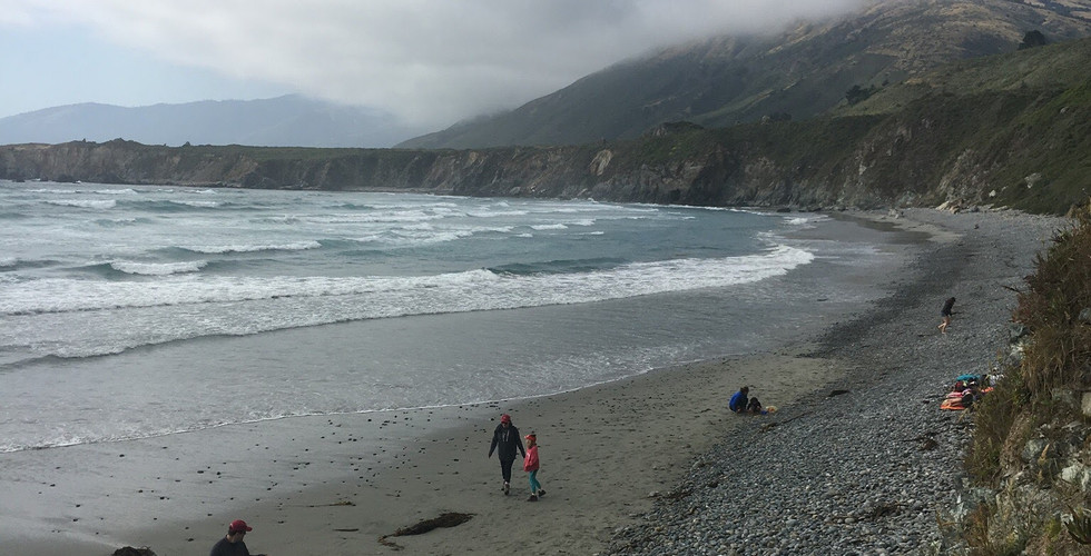
The way back down was a relaxed trot. When we got back to the Highway, a quick stop on the beach was in order! (Also a good call if you’re looking to get rid of any poison oak before hopping in the car). We were dehydrated and our calves ached from the constant downhill, but spirits were high when we dove into the ocean. Some strangers on the beach even shared a whole watermelon with us! He must have been sympathetic when he saw us all carrying our packs in the heat!


My advice to other backpackers:
1. Look out for poison oak!
The wooded areas are chalked full of this stuff, and unless you bring some kind of ointment or treatment for it, you might feel it’s full wrath by the time you get back to camp. It can get on your clothes, in your sleeping bag, and just about anywhere you don’t want it, so stick to the trail! My roommate was unlucky enough to get a healthy helping of poison oak on his face… he couldn’t sleep for almost a week afterward!

2. Research!
Be prepared! Be sure to do your research before you go, so you know where you can refill on water and potential backups for places to camp. Thank goodness there weren’t any goats at Goat Camp, or we would have really been in trouble! If you want to see the hiking route we took, here’s a great guide:
3. Enjoy the moment!
Here’s what I learned from my attempted backpack to Cone Peak: The key to enjoying the outdoors isn’t to focus on the destination. Nature is a lot like music, in my opinion. It’s not about the end goal, it’s about the journey. I was lucky enough to have a group that was fine not making it to Cone Peak, fine having to camp in a less than convenient position, and fine with being stung by poison oak. And this rubbed off on me (no pun intended, although I did literally end up with poison oak on both legs in the weeks after). My friends reminded me that if you do anything while backpacking, you should enjoy where you are, not where you’re about to be. The grass is always greener, unless you take a moment to appreciate where you are standing.


Comments